
Chapter 7 -
Rivers of Assam
1. 1. Write the short answer—
(a) What is the name of the glacier at the source of the Brahmaputra River?
Answer: The glacier at the source of the Brahmaputra River is called Chema-yung-dung.
(b) What is the total length of the Brahmaputra River?
Answer: The total length of the Brahmaputra River is 2,906 km.
(c) In which country is the source of the Brahmaputra?
Answer: The source of the Brahmaputra is in China.
(d) What is the shape of the river course in the high-speed region?
Answer: In high-speed areas, the river course is shaped like the letter U.
(e) Through which countries does the Brahmaputra flow?
Answer: The countries through which the Brahmaputra flows are:
1. Tibet
2. China
3. 3. India.
4. Bangladesh Adi.
2. The Write the correct answer
(a) Topography of the lowland/estuarine/upland area of the canyon.
answer- highland
(b) The gumpy form of rivers is usually found in mountains/plains/plains.
answer- the plain
(c) Char-chaparis in floodplains are formed by excavation/transportation/sedimentation of rivers.
answer- projection
(d) The Barak River flows through 2/3/4 districts of Assam.
answer- 3 hours ǀ
3. The Matching the right with the left
answer-
4. Typing —
( a ) Function of the upstream section of the river
Answer: The primary or high course of the river is almost confined to the hilly high ground. This part of the river begins at the source of the mountains and is captured until it lands on the plains. In the mountainous regions, the slope of the land is steep, the earth-nature is constrained, and it is composed of hard and soft rocks।The part of a river that descends or flows from a mountain is called upstream. When the river flows along the steep slopes of the mountains, the speed of the river increases and the excavation of the river bed increases. In this section, rivers carry rocks, sand, and soil in their currents. The river course resembles the English letter v. Deep canyons are also formed in places.
(b) Function of the middle section of the river.
Answer: The river flows slowly in this section as it flows through low slopes. The river has low carrying capacity in this section. As a result, rivers deposit rock, sand and soil carried by currents from the mountains in the plains. Rivers have low dredging capacity. In the middle of the river, the course is curved due to lateral excavation and sedimentation, which is also called the river spiral. During the dry season, sedimentation forms char chaparis and the water of the river divides into several branches due to these. Such forms of rivers are called gumphi forms. However, these disappear when the river water rises during the monsoon season.
(c) The function of the downstream section of the river.
Answer: At low tide, the river falls into the sea or ocean. The river is very slow at low speeds. The river has many branches. The river precipitates sand, clay and mud carried by the current into its estuary. This results in the formation of an island in the shape of an Assamese “B”. These islands are called the B-islands ǀ
( d ) The course of the Barak River.
Answer: The Barak River originates in the Maram area on the border with Manipur. The river flows southwest through Manipur from its source and then moves north again on the Manipur-Mizoram border. It flows north along the border of Assam and Manipur and then turns west to join the tributary Jiri. The river flows through Kachar district of Assam and through the northern parts of Hailakandi and Karimganj districts. The river splits into two parts on the Indo-Bangladesh border. One part of them enters Bangladesh under the name of Kushiara and the other part under the name of Surma. After a short distance, the two branches merge again under the name of Meghna and join the Padma in the Bay of Bengal. The Bar3ak River is about 900 km long. It is about 30 meters to 300 meters wide. There are about 27 small and large tributaries in the Assam section of the Barak River. The course of the river is very winding in the Assam and Bangladesh sections. There are numerous swamps on both sides of the river in the Kachar section. In Bangladesh, the river has taken a gumpy form.
5. 5. Why are most of the courses of the Brahmaputra River spiral?
Answer: Slow-moving currents on gentle slopes also have low riverbed excavation capacity. Therefore, the amount of bed mining in Assam is low. However, in contrast, the Assam part of the river is more eroded. The river causes severe erosion on both sides due to the soft soil structure on both sides of the river. Sedimentation occurs on the other bank of the river as opposed to the bank on which side excavation takes place. These lateral excavations and sediments cause the course of the Brahmaputra River to become curved or spiral.
6. 6. Write down the names of the parts of the Brahmaputra River from its source to its mouth.
Answer: Tibet-Chema-Yung-Dung Glacier (origin)
Tibet- Changpo
Arunachal Pradesh (Northern Part) - Chiang Mai
Arunachal Pradesh (Pasighat)- Dihang
Assam-Bahmaputra
Bangladesh-Padma (confluence with the Ganges)
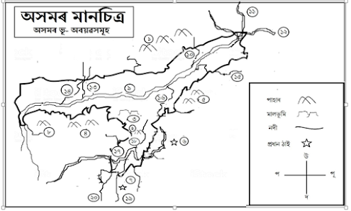
7. 7. Draw a map of the North East region of India and place the following objects with the help of geographical maps.
Answer:
8. 8. Write down the relationship of the people living along the river or tributary with the river or tributary.
Answer: People living along the banks of a river or tributary develop a close relationship with that river or tributary. People use the water of rivers to meet their various needs. For example, river water is needed for food , smoking, agriculture, and various industries. The floodplains created by the sediment left by the rivers every year during the rainy season are very suitable for agriculture. People in riverine areas benefit greatly from transportation. Riverside areas can often be excellent places for recreation. People have also been able to turn it into a business by catching small and large fish available in the river. The above facilities have created a close relationship between rivers and people.
9. Prepare an album by collecting photographs of floods and erosion published in newspapers , magazines etc.
Answer: You guys do it.
10. 10. Name the tributaries of the Brahmaputra on the southern bank from Guwahati to Dibrugarh. Get the help of teachers and maps if necessary. .
Answer: The tributaries of the Brahmaputra on the southern bank from Guwahati to Dibrugarh are the Budhidihing, Dikhou, Bhogdai, Jaji, Dhansiri, Kalang, Kapili, Jamuna and Bharlu ǀ


